The Dubai 2040 Urban Master Plan is the government's 20-year spatial plan for the emirate, launched in March 2021. It plans for the population to grow from 3.3 million in 2020 to 5.8 million in 2040 and concentrates that growth in urban centres: Deira and Bur Dubai, Downtown and Business Bay, and Dubai Marina and JLT, which exist today, plus two new centres at Expo 2020 and Dubai Silicon Oasis, with Jebel Ali earmarked for after 2040. It also doubles green and recreational space, grows public beaches from 21 km to 105 km and sets 60% of the emirate aside as nature reserves and rural natural areas.
Key takeaways
- Dubai 2040 is the emirate's seventh development plan since 1960, launched by the Government of Dubai in March 2021 and run by Dubai Municipality.
- Growth is steered into urban centres: three existing (Deira and Bur Dubai, Downtown and Business Bay, Dubai Marina and JLT) and two new (Expo 2020 and Dubai Silicon Oasis), with Jebel Ali earmarked for after 2040.
- The plan provides for 5.8 million residents and a daytime population of 7.8 million by 2040, up from 3.3 million and 4.5 million in 2020.
- Green and recreational space doubles, public parks land rises from 21.7 to 42.8 sq km, and public beaches grow from 21 km to 105 km.
- New building is contained inside the urban area, with no new offshore reclamation until environmental studies are complete.
- Since 2021 the plan has been followed by the public beaches plan, the Metro Gold Line and, in October 2026, an Urban Centres Development Plan for six main centres and 42 sub-centres.
- The plan sets targets for people, land and services. It is not a forecast of prices or rents, so judge each project on its own merits.
The Dubai 2040 Urban Master Plan is the rulebook behind where Dubai grows next. It decides where the government wants homes, offices, parks, beaches and transport, and it shapes every lower-level master plan, including the ones developers draw for their communities.
This guide sets out what the plan says, using the figures the Government of Dubai and Dubai Municipality have published, and maps its urban centres to the areas on our site. It covers what has been approved since the launch and what the plan does not tell you. For the wider picture of the city's districts, see our Dubai areas page.
Jump to: what the plan is, the urban centres, the targets, parks and beaches, the 20-minute city, what has been approved, what it means for buyers.
01What is the Dubai 2040 Urban Master Plan?
It is the Government of Dubai's 20-year spatial plan for the emirate, launched in March 2021 and managed by Dubai Municipality. The Dubai Media Office described it as the seventh development plan for Dubai since 1960.
The plan covers metropolitan Dubai and Hatta, which has its own development plan folded into it. Dubai Municipality describes it as a structure plan: a set of strategies, principles and policies that guide the more detailed plans below it, from area frameworks down to individual master communities.
Why a new plan was needed
Dubai has grown very quickly. The Dubai Media Office put the population at about 40,000 in 1960 and 3.3 million at the end of 2020, and the urban and built area at about 170 times its 1960 size of 3.2 sq km.
Dubai Municipality's summary of the plan describes the result: dense apartments near the old centres, newer centres that are mostly high-rise, and large low-density villa areas, some of them without transit. Many newer developments were only partly built. The 2040 plan's answer is to grow inside the existing urban area, densify around centres and stations, and protect the land outside it.
The plan's eight goals
Dubai Municipality lists eight goals for the plan. In short, they are:
- Make better use of space and infrastructure.
- Plan vibrant, healthy communities with a range of housing and core facilities.
- Provide more parks and open space.
- Improve access with a people-centred approach.
- Make economic land work better.
- Improve environmental quality and resilience.
- Protect heritage, archaeology and places of cultural significance.
- Apply planning rules consistently across the emirate.
Each goal has indicators the government uses to track progress. They include the share of the population within 800 metres of a public transport station, open space per person, the share of publicly accessible waterfront and the share of trips made on foot, by bicycle and by public transport.
The four kinds of land
The plan divides the emirate into four areas, and the split matters for buyers because it decides where new communities can go.
| Area | What the plan says |
|---|---|
| Urban | Where most existing development is and where all future growth is to be contained. Population density in the urban area rises as a result |
| Peri-urban | Between the urban and rural areas. Low to medium density, scheduled to become mixed-use, and much of it held as land bank for growth after 2040 |
| Rural | Mostly wilderness, conservation areas, farms and rural settlements. New development is not permitted unless it fully complies with the plan |
| Marine | Dubai's waters out to 12 nautical miles, including artificial islands. No further reclamation until key environmental studies are complete |
Two consequences stand out. Greenfield growth outside the urban area is discouraged, and the plan sets a moratorium on new offshore reclamation, other than ecological restoration, until environmental studies are done. Island projects already under way, such as Dubai Islands and Palm Jebel Ali, sit within existing commitments.
02What are the urban centres in the Dubai 2040 plan?
The plan concentrates jobs, services and density in urban centres. At the launch the government named five: three that exist today and two new ones to be developed by 2040. Dubai Municipality's structure plan also earmarks Jebel Ali as a sixth centre for development after 2040.
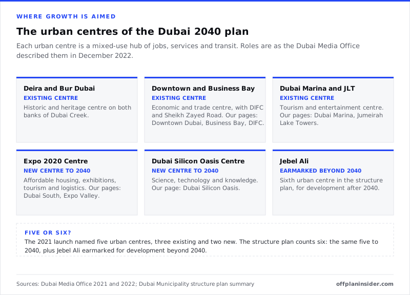
An urban centre is not a single building or district boundary. It is the top tier of a hierarchy of mixed-use centres, where the plan wants the highest concentration of jobs and city-wide services, all served by public transport.
The three existing centres
Deira and Bur Dubai. The historic and heritage centre, on both banks of Dubai Creek. The plan keeps it as a focus for jobs, retail, culture and recreation while respecting heritage boundaries. The nearest new waterfront community on our site is Dubai Islands, off the Deira coast.
Downtown, Business Bay, DIFC and Sheikh Zayed Road. The economic and trade centre. Our pages for Downtown Dubai, Business Bay, DIFC and Sheikh Zayed Road cover the projects on sale here.
Dubai Marina and Jumeirah Lake Towers. The tourism and entertainment centre. See Dubai Marina and Jumeirah Lake Towers.
The two new centres
The Expo 2020 Centre. Built around the former Expo site, it is described as a centre for affordable housing, exhibitions, tourism and logistics. Dubai Municipality's summary also positions the southern emirate as a logistics and production hub linked to Al Maktoum International Airport, Jebel Ali Port and Etihad Rail.
On our site this centre takes in Dubai South, Expo Valley and Emaar South. Our guides to living in Expo City Dubai and living in Dubai South cover daily life there.
| Project | Developer | Homes | From | Payment plan | Handover | Status |
|---|---|---|---|---|---|---|
| Divine Elements | Takmeel Real Estate Development | Apartment | AED 600K | 20/20/60 | On request | Selling |
| Vivida Residences | Namo Development | Apartment | AED 680K | 5/30/65 | Q1 2028 | New launch |
| Lincoln Star Residence IV | Lincoln Star Group | Apartment | On request | On request | Q2 2028 | Pre-launch |
| Avenew 888 | Avenew Development | Apartment · Duplex | AED 1.45M | 10/50/40 | Q1 2028 | Selling |
| WAADA by BT Properties | BT Properties | Apartment · Townhouse · Villa | On request | 70/30 | Q4 2028 | Under construction |
| Calisi by Zoya | Zoya Developments | Apartment | On request | On request | Q3 2027 | Under construction |
| Galleria Residences | Evera Development | Apartment | AED 809K | 30/70 | Dec 2027 | Under construction |
| X11 by BAMX | BAMX Developments | Apartment | AED 920K | On request | Q4 2028 | New launch |
| Elinor by Zoya | Zoya Developments | Apartment | AED 647K | 20/25/5/50 | Q3 2028 | New launch |
| Miorah by Zoya | Zoya Developments | Apartment | On request | On request | Q2 2027 | Selling |
| Tessera | Al Ghurair Development | Apartment · Duplex | AED 2.1M | 35/65 | Q2 2028 | New launch |
| Al Ghaf Janoub | Jersey Real Estate Development | Apartment · Commercial | On request | On request | On request | Pre-launch |
| Enre Residence by Imtiaz | Imtiaz Developments | Apartment | On request | 20/40/40 | Q1 2028 | Under construction |
| Samana Hills South 3 | Samana Developers | Apartment | AED 999K | On request | Q4 2028 | Selling |
| Samana South Haven | Samana Developers | Apartment | AED 599K | On request | Q2 2029 | Selling |
| Samana South Haven 2 | Samana Developers | Apartment | AED 644K | On request | On request | New launch |
| Cresswell Homes | Merath Development | Apartment | On request | On request | On request | Selling |
| Azizi Venice 6 | Azizi Developments | Apartment | AED 705K | 10/10/10/10/60 | On request | Selling |
| Monaco Mansions | Azizi Developments | Villa | AED 45M | 10/70/20 | Dec 2026 | Selling |
| Coventry 49 | GFS Developments | Apartment | AED 633K | 20/24/20/36 | Q2 2028 | Selling |
The Dubai Silicon Oasis Centre. A centre for science, technology and knowledge. Dubai Municipality's summary links it to an advanced production zone in the north-east of the city. The Metro Blue Line is planned to reach it; see our guide to the Dubai Metro Blue Line and our Dubai Silicon Oasis page.
| Project | Developer | Homes | From | Payment plan | Handover | Status |
|---|---|---|---|---|---|---|
| Greenwoods by Aldar | Aldar Properties | Villa · Townhouse | On request | 55/45 | On request | Pre-launch |
| The Hillgate | Ellington Properties | Apartment · Duplex | On request | On request | On request | Under construction |
| Timez by Danube | Danube Properties | Apartment · Commercial | AED 1.28M | 40/60 | Q2 2028 | Under construction |
Jebel Ali after 2040
The structure plan earmarks Jebel Ali as a sixth urban centre for development beyond 2040. Today the area includes Downtown Jebel Ali, Palm Jebel Ali and the community covered in our Jebel Ali Village guide. Being earmarked for after 2040 says nothing about the homes being built there now; it describes the city-level centre the plan has in mind for later.
03How is the city organised below the urban centres?
Below the urban centres sit five more levels, each planned around a population band. The level decides what services a place is planned to have, from a corner shop and a nursery up to hospitals and universities.
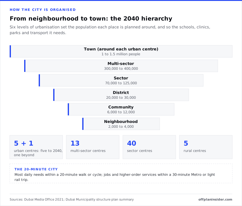
| Level | Planned population | Centres in the structure plan |
|---|---|---|
| Town (around an urban centre) | 1 to 1.5 million | 5 urban centres to 2040, 1 beyond |
| Multi-sector | 300,000 to 400,000 | 13 |
| Sector | 70,000 to 125,000 | 40 |
| District | 20,000 to 30,000 | Set in detailed master plans |
| Community | 6,000 to 12,000 | Set in detailed master plans |
| Neighbourhood | 2,000 to 4,000 | Set in detailed master plans |
For buyers, the useful idea is that higher-order centres get the Metro or light rail, and lower-order centres are linked by bus and by walking and cycling routes. Dubai Municipality's summary says the vast majority of future offices and most future hotel land are to be allocated in centres. It also says future mall development is not recommended beyond current commitments, with street retail the focus instead.
04What are the Dubai 2040 population and land targets?
The plan provides for 5.8 million residents by 2040, from 3.3 million in 2020, and changes how land is shared between uses. The headline targets are below.
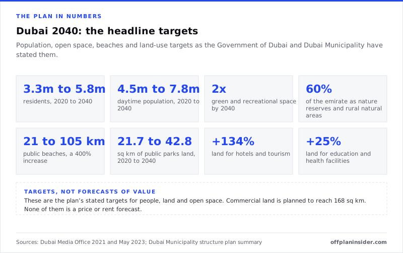
| Measure | 2020 | 2040 target |
|---|---|---|
| Residents | 3.3 million | 5.8 million |
| Daytime population | 4.5 million | 7.8 million |
| Employment: residents and commuting workers | 2.8 million | 4.9 million |
| Public parks land | 21.7 sq km | 42.8 sq km |
| Public beaches | 21 km | 105 km |
| Hotel and tourism land | – | Up 134% |
| Education and health facility land | – | Up 25% |
| Commercial land | – | 168 sq km |
| Nature reserves and rural natural areas | – | 60% of the emirate |
What the population figures mean
The plan's own words are that residents will increase by almost 75% over two decades. Dubai Municipality's summary adds that the land and floorspace needed for that growth does not exceed the unbuilt land already allocated for future development. In other words, the plan expects growth to fill land already zoned, not to spread into the desert.
The summary also says density in the urban area rises as growth is contained. Densities are to peak at the centres and fall between them, leaving space for green corridors.
Housing in the plan
The plan's housing chapter focuses on supply that matches demand, staged growth, more housing types and affordable homes near centres and transit. It identifies singles and families on lower incomes without employer housing as needing affordable housing support.
The phase II approval in December 2022 included a Dubai real estate strategy to 2040 aimed at balancing supply and demand. The number of homes Dubai needs by 2040 is to come from an Affordable Housing Framework, and no single citywide housing target is given in the summary.
05How much green space and beach does Dubai 2040 add?
Green and recreational space doubles by 2040, public parks land roughly doubles from 21.7 to 42.8 sq km, and public beaches grow from 21 km to 105 km. Nature reserves and rural natural areas make up 60% of the emirate.
Parks and green corridors
Dubai Municipality's summary plans about 13.6 sq km of new city-level parks, a clear hierarchy from small local parks to large ones, and green corridors joining major parks, natural areas and centres. The corridors double as walking and cycling routes and help cool areas affected by urban heat.
The plan also introduces conservation, desert and marine parks with limited public use, such as hiking and birdwatching, and proposes larger nature reserves, including a new reserve at Margham. All unzoned rural land is designated wilderness.
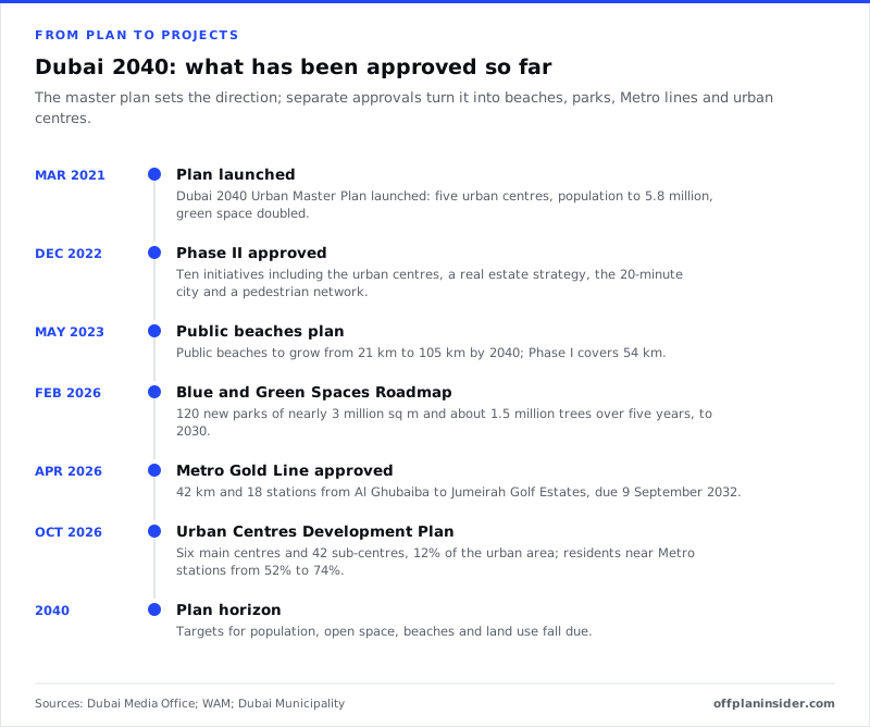
In February 2026 the Government of Dubai reviewed a Blue and Green Spaces Roadmap 2030 aligned with the 2040 plan. It covers projects worth more than AED 4 billion, 120 new parks covering nearly 3 million sq m and about 1.5 million trees over five years.
Public beaches
In May 2023 the government approved a Dubai Master Plan for Public Beaches. It grows public beaches from 21 km to 105 km by 2040, adding 84 km, with 54 km in its first phase. Jebel Ali Public Beach, Al Mamzar and the Jumeirah and Umm Suqeim beaches are named in it.
Delivery is visible already. Khor Al Mamzar Beach reopened in May 2026 with its swimming shoreline extended to 3.6 km and a 300-metre night beach open around the clock. The plan's coastal policy also aims for uninterrupted public access along the shore, prioritising undeveloped waterfront for public beaches.
For buyers who want to live near the sea, our guide to beachfront property in Dubai covers the beach communities with homes on sale.
06What is the 20-minute city?
It is the plan's aim that residents reach most daily needs within 20 minutes on foot or by bicycle, and work and major services within 30 minutes by Metro or light rail. The policy was approved in the second phase in December 2022.
The Dubai Media Office described the target as access to 80% of daily needs within 20 minutes, with higher population density around mass transit stations. Dubai Municipality's summary adds a 30-minute Metro or light rail trip to work for all residents.
The transit tiers
The plan sorts transport into tiers. Tier 1 is the Metro. Tier 2 is light rail and marine transport. Tier 3 is local and feeder buses. Walking, cycling and e-scooters make up soft mobility.
Higher-order centres are to be connected by Metro or light rail, lower-order centres by bus and soft mobility. Most offices are to be within walking distance of tier 1 and 2 stations, to cut car trips to work.
How to use this when choosing a home
Look at the real walking distance from a project to a current or confirmed station, not the drive time in a brochure. Then look at what sits within a 20-minute walk: a school, a clinic, a supermarket, a park.
A community that already has these, or has them under construction, fits the plan's model. One that relies on a planned station or a school plot is a longer wait. Our guide to off-plan family communities near schools covers the school side in detail.
07What has been approved since 2021?
The master plan sets direction; separate approvals turn it into projects. Since the launch, the government has approved a second phase of the plan, a public beaches plan, a parks and beaches roadmap, the Metro Gold Line and an Urban Centres Development Plan.
Phase II, December 2022
The second phase grouped projects under ten initiatives, including enhancing the urban centres, a Dubai real estate strategy, an urban farming plan, a heritage plan, the 20-minute city policy and a pedestrian network master plan. At the same review the government reported that phase I had included a national housing policy with an AED 65 billion budget and the Hatta development master plan.
The Metro Gold Line, April 2026
The Gold Line was approved in April 2026 as Dubai's first fully underground Metro line: about 42 km and 18 stations, with an investment of around AED 34 billion and an opening date of 9 September 2032. Its route runs from Al Ghubaiba through Mina Rashid, City Walk, Business Bay, Mohammed Bin Rashid City, Nad Al Sheba, Meydan, Al Barsha South and Jumeirah Village Circle to Jumeirah Golf Estates.
The Roads and Transport Authority described the line as addressing urban and population growth in line with the 2040 plan. It links with the Red Line at Business Bay and Jumeirah Golf Estates, the Green Line at Al Ghubaiba, and Etihad Rail at Meydan and Jumeirah Golf Estates. Our pages for Mohammed Bin Rashid City, Nad Al Sheba, Jumeirah Village Circle and Jumeirah Golf Estates list projects along the route.
The Urban Centres Development Plan, October 2026
In October 2026 the Executive Council of Dubai approved an Urban Centres Development Plan, overseen by the Supreme Committee for Urban Planning and Dubai Municipality. It covers six main urban centres and 42 supporting sub-centres, about 12% of Dubai's urban area, with a budget of more than AED 2 billion to 2040.
Its targets are to raise the share of residents living around Metro stations from 52% to 74%, and public services coverage from 74% to 85%. It rests on three pillars: quality of life, economic returns, and the efficiency and cost of infrastructure. Our news story on the Urban Centres Development Plan covers the announcement; the individual sub-centres have not been named.
08What does the Dubai 2040 plan mean for off-plan buyers?
It tells you where the government wants growth, services and transport to go. It does not tell you what any home will be worth, and it does not replace checking the project itself.
How to use the plan
- Start with the centres. Projects in or near an urban centre, or on a confirmed Metro route, sit where the plan concentrates jobs and services.
- Check the transport is real. Separate approved lines, such as the Blue Line and the Gold Line, have dates. A line drawn on a plan map does not.
- Look at the 20-minute radius. List what is open within a walk of the project today, and what is under construction.
- Check the land type. New communities in the urban area fit the plan; development outside it needs to show full compliance with the plan.
- Read the developer's own master plan. The 2040 plan guides it, but the community's own approvals, phasing and handover dates are what you are buying into.
What the plan does not do
It does not rank areas, guarantee delivery dates for individual projects or forecast prices and rents. Its own summary notes that its findings come from studies conducted in 2019 to 2021 and will be updated through later studies and framework plans.
For the step-by-step purchase, see our guide on how to buy off-plan property in Dubai. For where the newest communities are, read new areas in Dubai, and for which areas international buyers can own in, see freehold areas in Dubai.
09Key terms
Structure plan. The top-level spatial plan for the emirate. It sets strategy and policy and guides the more detailed plans below it.
Urban centre. The highest tier of mixed-use centre, with the greatest concentration of jobs and city-wide services, served by public transport.
Transit-oriented development. Building homes, jobs and services densely around public transport stations.
Land bank. Land outside the 2040 development footprint, held for growth after the land inside the footprint has been used.
Soft mobility. Walking, cycling and e-scooters.
Framework plan. A detailed plan for a topic or an area that turns the structure plan's policies into rules a developer must follow.
10Checklist: reading a project against the 2040 plan
- Is the project in or near one of the urban centres, or on an approved Metro line?
- What is the walking distance to the nearest open or approved station?
- Which schools, clinics, shops and parks are open within a 20-minute walk?
- Which of those are under construction, and when are they due?
- Is the community in the urban area of the plan?
- Does the developer's master plan show phases and dates for the amenities you need?
- Is the project registered with the Dubai Land Department, with an escrow account, before you pay?
ProjectsProjects mentioned in this guide.
FAQQuestions buyers ask.
What is the Dubai 2040 Urban Master Plan?
It is the Government of Dubai's 20-year plan for how land in the emirate is used, launched in March 2021 and managed by Dubai Municipality. It sets where homes, jobs, parks, beaches and services go, around a set of urban centres linked by public transport, and covers both metropolitan Dubai and Hatta.
What are the five urban centres in the Dubai 2040 plan?
Three existing centres: Deira and Bur Dubai; Downtown and Business Bay, with DIFC and Sheikh Zayed Road; and Dubai Marina and JLT. Two new centres: the Expo 2020 Centre and the Dubai Silicon Oasis Centre. Dubai Municipality's structure plan adds Jebel Ali as a sixth centre earmarked for development beyond 2040.
What population does Dubai 2040 plan for?
5.8 million residents by 2040, up from 3.3 million at the end of 2020. The daytime population, which includes people who commute in and visitors, is planned to rise from 4.5 million to 7.8 million.
How much green space and beach does the plan add?
Green and recreational space is to double by 2040, and land for public parks rises from 21.7 sq km in 2020 to 42.8 sq km, including about 13.6 sq km of new city parks. Public beaches grow from 21 km to 105 km, a 400% increase. Nature reserves and rural natural areas make up 60% of the emirate.
What is the 20-minute city in Dubai?
A policy approved in the plan's second phase in December 2022. The aim is for residents to reach most of their daily needs within 20 minutes on foot or by bicycle, with access to 80% of daily needs in that time, and to reach work and major services within a 30-minute Metro or light rail trip.
Does the Dubai 2040 plan say which areas will rise in value?
No. The plan sets targets for population, land use, open space and transport. It does not forecast prices or rents for any area. Use it to understand where services and transport are planned, then check each project's own facts.
Is Dubai Silicon Oasis part of the 2040 plan?
Yes. The Dubai Silicon Oasis Centre is one of the two new urban centres to be developed by 2040, focused on science, technology and knowledge. The Metro Blue Line is planned to serve it.
Where can I read the Dubai 2040 plan itself?
Dubai Municipality publishes an executive summary of the plan on its website, alongside the Beach Guidelines issued under the plan. The Government of Dubai's launch statement and later approvals are on the Dubai Media Office site.
Sources & methodWhere these figures come from.
Sources
- mediaoffice.ae: Mohammed bin rashid
- mediaoffice.ae: Mohammed bin rashid
- dm.gov.ae: Dubai 2040 urban master plan
- dm.gov.ae: Dubai 2040 urban master plan 2040 executive summary
- dmpmedia.dm.gov.ae: Dubai 2040 Urban Master Plan 2040 Executive Summary v1.pdf
- dm.gov.ae: Beach Guidelines Dubai 2040 Initiative.pdf
- UAE Government portal: Dubai 2040 urban master plan
- mediaoffice.ae: Mohammed bin rashid approves master plan for dubai public beaches
- mediaoffice.ae: Dubai municipality opens khor al mamzar beach to the public
- mediaoffice.ae: Mohammed bin rashid reviews dubai blue and green spaces roadmap 2030 at wgs 2026
- wam.ae: Bzuf93q mohammed bin rashid approves dubai metro’s gold
- wam.ae: C2ycqr1 hamdan bin mohammed affirms public wellbeing
What we could not verify
- The plan was launched in 2021 as five urban centres, and the Dubai Municipality structure plan summary counts six (adding Jebel Ali beyond 2040); the October 2026 Urban Centres Development Plan also covers six main centres. The six main centres of the 2026 plan and its 42 sub-centres have not been named, so we cannot yet say which communities are included.
- The plan's targets are government plans for 2040. Phasing, budgets and delivery dates of individual projects can change, and the plan itself says its findings will be updated through later studies and framework plans.
- Which of our area pages fall inside each urban centre is our own mapping by name and location. The plan's centre boundaries are drawn on its maps, not listed street by street.
5 Nov 2026 · Reviewed by OffPlan Insider Research. First published 5 Nov 2026, updated 9 Nov 2026. Data: plan figures are as stated by the Dubai Media Office, Dubai Municipality and WAM between March 2021 and October 2026; the project tables are from OffPlan Insider project data on the date this page was last updated.